Table of Contents
- What Are Celestial Coordinate Systems?
- Right Ascension and Declination: The Equatorial Grid
- Alt-Azimuth Coordinates: The Observer’s Horizon System
- Ecliptic Coordinates, Precession, and the Role of the Equinox
- Galactic Coordinates and the Milky Way Reference Frame
- Timekeeping for the Sky: Sidereal Time, Hour Angle, and Seasons
- Converting Between RA/Dec and Alt-Az: Practical Formulas
- How to Use Coordinates in Real Observing and Planning
- Common Pitfalls, Best Practices, and Accuracy Tips
- Frequently Asked Questions
- Final Thoughts on Mastering Celestial Coordinates
What Are Celestial Coordinate Systems?
Celestial coordinate systems are the frameworks astronomers use to describe the positions of objects on the celestial sphere. Think of them as the sky’s equivalent of latitude and longitude, optimized for different tasks like finding stars, tracking planets, or mapping the Milky Way. Because Earth rotates and orbits the Sun, and because the sky itself slowly shifts due to the precession of Earth’s axis, multiple coordinate systems coexist to make sense of a dynamic sky.
At their core, coordinate systems encode two angles that pinpoint where to look. Different systems choose different reference planes and zero-points:
- Equatorial coordinates (Right Ascension and Declination) align with Earth’s equator projected onto the sky.
- Horizontal coordinates (Altitude and Azimuth) anchor to the local horizon of the observer.
- Ecliptic coordinates align with the plane of Earth’s orbit—the path the Sun appears to trace in the sky.
- Galactic coordinates align with the plane of the Milky Way’s disk, ideal for mapping our galaxy.

Artist: Jim slater307
Each system has strengths. If you want to star-hop across a chart, equatorial is king. If you want to know what is up from your backyard right now, the horizontal system is the most intuitive. If you want to visualize the motion of planets and the Sun, the ecliptic is indispensable. If you’re exploring the structure of the Milky Way, galactic coordinates shine.
In this guide, we’ll demystify each system and show how to convert between them. Along the way, we’ll cover sidereal time, precession and the equinox, and practical tips for using coordinates in planning and observation.
Right Ascension and Declination: The Equatorial Grid
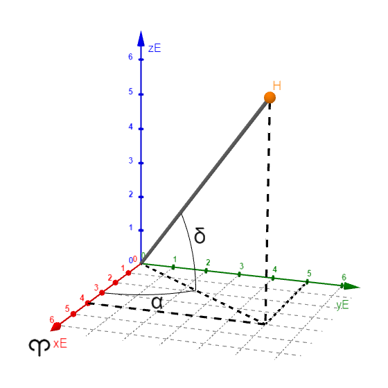
The equatorial coordinate system is the most widely used framework for fixed stars and deep-sky objects. It projects Earth’s equator onto the sky as the celestial equator and the North and South poles as the celestial poles. The two coordinates are:
- Declination (Dec, δ): the angular distance north or south of the celestial equator, measured in degrees (°), from −90° (south celestial pole) to +90° (north celestial pole). It is analogous to geographic latitude.
- Right Ascension (RA, α): the angular distance measured eastward along the celestial equator from a zero-point called the vernal equinox (the point where the Sun crosses the celestial equator each March). RA is usually expressed in hours, minutes, and seconds, from 0h to 24h, because Earth’s rotation naturally maps to time.
Artist: Lamid58
Why RA in hours? Because as Earth rotates 360° in about 24 hours, 1 hour of RA corresponds to 15° of sky rotation. When the local sidereal time (LST) matches an object’s RA, that object crosses your local meridian and reaches its highest altitude for the day.
Epochs and Precession
Coordinates must specify an epoch, such as J2000.0, to account for the sky’s slow drift due to precession (a roughly 26,000-year wobble of Earth’s axis) and the smaller effect of nutation. Catalogs commonly use RA/Dec (J2000.0) or sometimes (B1950.0) in older literature. Some modern software can precess positions to the current date (often labeled “of-date”).
Important considerations:
- Precession: shifts the coordinate grid relative to the stars by about 50 arcseconds per year.
- Proper motion: some nearby stars move discernibly across the sky over decades; catalogs note proper motions in RA and Dec.
- Parallax: causes seasonal apparent shifts for nearby objects due to Earth’s orbit; generally important in high-precision astrometry.
Practical Uses of RA/Dec
- Star charts and atlases: Printed and digital charts use equatorial grids and RA labels to help you navigate.
- GoTo mounts: Equatorial mounts and GoTo systems accept RA/Dec (epoch specified) to slew directly to targets.
- Astronomy software: Planetarium apps often default to RA/Dec for search and logging.
If you are trying to understand when an object culminates or how its altitude changes during the night, pair RA/Dec with sidereal time and hour angle.
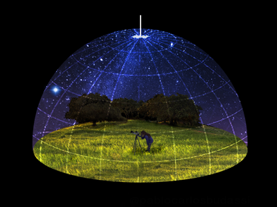
Alt-Azimuth Coordinates: The Observer’s Horizon System
The horizontal, or alt-azimuth, coordinate system is tied to the observer’s location and the current time. It is intuitive because it uses directions familiar from everyday life:
- Altitude (Alt): the angle above the horizon, from 0° at the horizon to +90° at the zenith.
- Azimuth (Az): the direction along the horizon, typically measured from true north through east (0° = north, 90° = east, 180° = south, 270° = west). Some traditions use south as zero, so always check the convention.
Artist: Pablo Carlos Budassi
Because Earth rotates, an object’s Alt-Az changes minute to minute. Planets rise in the east, culminate in the south (for mid-northern latitudes), and set in the west. For observers using dobsonian or other alt-az mounts, this system describes the motion you physically perform at the eyepiece.
Local and Temporal Dependence
Alt-Az depends on:
- Observer latitude: which determines the height of the celestial pole above your horizon.
- Local sidereal time: which sets what RA is currently crossing your meridian.
- Refraction and conditions: near the horizon, atmospheric refraction significantly alters apparent altitude. See Common Pitfalls for details.
When you pull up a sky app and ask “what’s high in the sky right now?”, you are using Alt-Az. When you plan a session for targets above, say, 35° altitude (to avoid excessive air mass), you are speaking horizontal coordinates.
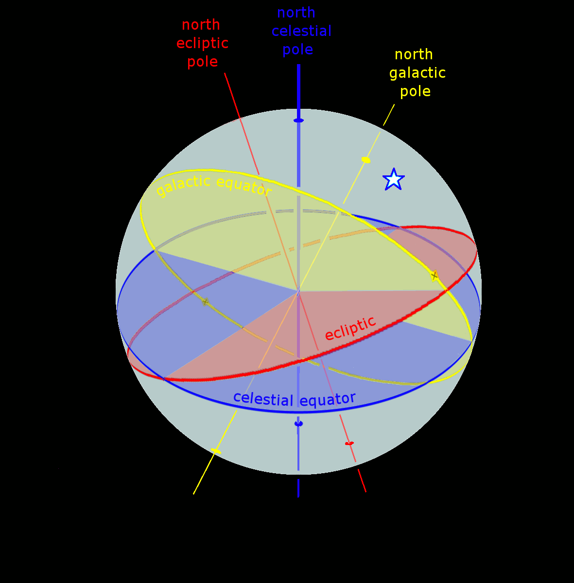
Ecliptic Coordinates, Precession, and the Role of the Equinox
The ecliptic is the plane of Earth’s orbit around the Sun. The Sun’s apparent path across the sky, the ecliptic, cuts the celestial sphere at an angle of about 23.44° relative to the celestial equator. This tilt is the obliquity of the ecliptic and explains seasons. Ecliptic coordinates are useful because the Moon and planets stay close to the ecliptic plane.

Artist: Tfr000
- Ecliptic latitude (β): angle north or south of the ecliptic.
- Ecliptic longitude (λ): measured along the ecliptic from the vernal equinox, the same reference point used to define RA=0h.
These coordinates feature prominently in planetary ephemerides and lunar observing. If you’re following the zodiacal constellations, you’re tracing the ecliptic. For planetary observers, the ecliptic explains why certain constellations host planets more often and why planetary altitudes vary seasonally for a given latitude.
Precession and the Equinox
The vernal equinox is not fixed against the background stars; it precesses westward along the ecliptic. This precession shifts the RA/Dec grid over time and subtly changes the ecliptic longitude of stars as measured against the equinox of date. That’s why precise positions always include an epoch (e.g., J2000.0). The nutation superimposes small periodic oscillations onto precession. Together, they are handled by standard astronomical models.
When Ecliptic Coordinates Matter
- Planetary observing and imaging: choosing nights when a planet rides high (large ecliptic altitude) improves seeing.
- Lunar libration and features: the Moon’s motion relative to the ecliptic influences visibility of features and shadows.
- Solar eclipses and occultations: path predictions rely on precise ecliptic-aligned mechanics.
If you want to translate a planet’s position into a sky position you can point to, you will pass through RA/Dec and then into Alt-Az for your location and time.
Galactic Coordinates and the Milky Way Reference Frame
The galactic coordinate system is aligned with the plane of the Milky Way. It is indispensable for mapping our galaxy’s structure, studying interstellar dust, or plotting the distribution of star clusters and nebulae.
- Galactic longitude (ℓ): 0° is defined toward the Galactic Center in Sagittarius, increasing in the direction of the Milky Way’s rotation.
- Galactic latitude (b): angle above or below the galactic plane; b=0° lies on the mid-plane of the Milky Way.
Artist: Tfr000
Galactic coordinates are ideal when you’re asking questions like, “How far above the Milky Way plane is this object?” or “Where is the Galactic Center relative to my observing site?” Observers who love Milky Way wide-field views or hunt for emission nebulae can use galactic maps to choose regions rich in targets.
To plan a night out, however, you’ll still convert to RA/Dec and ultimately to Alt-Az to know when and where to look. Tools and catalogs frequently provide transformations among these systems with the appropriate epoch and precession corrections.
Timekeeping for the Sky: Sidereal Time, Hour Angle, and Seasons
Time in astronomy is not only about clocks—it’s about Earth’s rotation relative to the stars. The concept of sidereal time underpins the connection between RA/Dec and what you see overhead.
Solar vs. Sidereal Day
A solar day (24 hours) is the interval between two successive noons. But because Earth orbits the Sun, it must rotate a little extra each day for the Sun to return to the same local meridian. A sidereal day, by contrast, measures a 360° rotation of Earth relative to distant stars and is roughly 23 hours, 56 minutes, and 4 seconds. This difference is why the stars return to the same positions about 4 minutes earlier each night and why constellations shift with the seasons.
Local Sidereal Time (LST)
LST tells you the RA crossing your meridian at a given moment. If LST = 10h, then objects with RA ≈ 10h are due south (for northern observers) and at their highest for that night. The beauty of LST is its direct mapping to RA.
To compute LST, you can start from Greenwich Mean Sidereal Time (GMST) and add your longitude (east positive, west negative). Many planetarium apps do this automatically, but for educational purposes an approximate algorithm is useful.
Approximate GMST formula (hours):
GMST ≈ 18.697374558 + 24.06570982441908 × Dwhere
Dis the number of days (including fraction) since J2000.0 (2000-01-01 12:00 UT). Reduce GMST modulo 24. ThenLST = GMST + (longitude in hours)with longitude in hours = (longitude in degrees)/15. Always normalize to 0–24 hours.
Once you have LST, you can compute the hour angle H for an object:
H = LST − RA
Hour angle is positive west of the meridian and tells you how long it has been since the object transited (crossed the meridian). H = 0 means the object is culminating.
Seasonal Visibility
Because the Sun’s RA changes along the ecliptic over the year, the night sky presents different RA ranges each season. For example, if the Sun’s RA is ~6h at a given time of year, the midnight sky favors RA around 18h (12 hours opposite the Sun along the celestial equator). This seasonal shift is why winter and summer skies show different constellations at the same clock time.
To plan targets, match your observing time to desired RA ranges using the relationship between LST, your longitude, and Universal Time. You’ll deepen your intuition by pairing a sky app’s “now” view with mental bookmarks of which RAs dominate in different months.
Converting Between RA/Dec and Alt-Az: Practical Formulas
Transforming equatorial coordinates into the horizontal system is essential for answering, “How high is it, and where on the horizon?”. The conversion uses your latitude, the object’s RA/Dec, and your Local Sidereal Time.
Inputs and Conventions
- Observer latitude: φ (positive north)
- Object coordinates: RA (α), Dec (δ)
- Local Sidereal Time: θ (LST)
- Hour Angle: H = θ − α (ensure consistent units: convert RA and LST to angles or hours as needed)
- Azimuth convention here: 0° = North, increasing toward East (0–360°)
Core Spherical Trigonometry
Compute altitude (a) and azimuth (A) using the standard relations:
sin(a) = sin(φ)·sin(δ) + cos(φ)·cos(δ)·cos(H)
cos(a) = sqrt(1 − sin(a)^2)   (for numerical stability, compute directly if desired)

sin(A) = −(cos(δ)·sin(H)) / cos(a)
cos(A) = (sin(δ) − sin(a)·sin(φ)) / (cos(a)·cos(φ))

A = atan2(sin(A), cos(A))  → convert to degrees, normalize to [0°, 360°)
A robust implementation uses atan2(y, x) to resolve the correct azimuth quadrant. Normalize angles at each step to avoid wrap-around issues.
Inverse Conversion (Alt-Az to RA/Dec)
To go the other way—Alt/Az to RA/Dec—you’ll use the inverse relationships. First compute the object’s hour angle from Alt-Az:
sin(δ) = sin(a)·sin(φ) + cos(a)·cos(φ)·cos(A)
δ = arcsin(sin(δ))

sin(H) = −(sin(A)·cos(a)) / cos(δ)
cos(H) = (sin(a) − sin(φ)·sin(δ)) / (cos(φ)·cos(δ))
H = atan2(sin(H), cos(H))

RA = LST − H
Again, normalize RA to 0–24 hours and angles to 0–360° (or −180°–+180° as preferred). These equations assume an azimuth measured from north through east. If your software or mount uses a different azimuth convention, adjust signs accordingly.
Accounting for Atmospheric Refraction
Near the horizon, refraction lifts objects higher than their geometric altitude. For many planning tasks above ~20° altitude, you can ignore refraction. When aiming low, a standard approximate correction (in arcminutes) for apparent altitude h (in degrees) is:
R ≈ 1.02 / tan( (h + 10.3 / (h + 5.11))° ) [arcminutes]
This empirical form works reasonably well for standard conditions. Real refraction varies with temperature, pressure, and humidity. Most planetarium tools provide refraction toggles or atmospheric models; consult them for low-altitude work. For high-precision astrometry, use dedicated refraction models with local meteorological inputs.
How to Use Coordinates in Real Observing and Planning
Knowing the definitions is only half the story. Here is how celestial coordinates help you plan sessions, navigate the sky, and set up equipment.
Planning What to Observe
- Match targets to your observing window: Use RA/Dec to select objects that culminate during your session. If your LST window is around 22h to 2h, focus on objects with RA in that range for optimal altitude.
- Apply altitude limits: Convert to Alt-Az using the formulas in Converting Between RA/Dec and Alt-Az to filter objects below, say, 30° altitude to minimize atmospheric effects.
- Seasonal themes: Use the relationship between the Sun’s RA and night-time RAs from Seasonal Visibility to choose seasonal showpieces.
Star-Hopping with Paper or Digital Charts
Equatorial grids on charts are your map. To star-hop:
- Find a bright “anchor” star near your target whose RA/Dec is close.
- Mentally translate chart directions: increasing RA is eastward on the sky; increasing Dec is northward (for standard chart orientations).
- Use angular separations (in degrees) and field-of-view estimates of your finder and eyepieces to step along patterns.
Even if you ultimately rely on GoTo, star-hopping builds a spatial intuition that makes coordinates feel natural.
Aligning Mounts and Pointing Systems
- Equatorial mounts: Polar alignment aligns the RA axis with the celestial pole. Once aligned, tracking in RA counters Earth’s rotation. Entering target RA/Dec lets the mount slew to fixed sky positions directly.
- Alt-az mounts: Two-star or multi-star alignment estimates the mount’s orientation relative to the horizon and meridian. Targets are transformed internally from RA/Dec to Alt-Az.
- Plate solving: Imaging systems take a short exposure and determine RA/Dec by matching star patterns; this bypasses manual input and corrects pointing errors.
Optimizing Image Quality
- Aim high: Objects above ~45° altitude suffer less atmospheric turbulence, dispersion, and extinction.
- Plan for meridian flips: Equatorial mounts may need a flip when hour angle crosses 0. Coordinate-aware scheduling minimizes disruptions.
- Follow the ecliptic for planets: Consult ecliptic coordinates to pick planets when they’re seasonally high for your latitude.
Worked Example (Conceptual)
Suppose your latitude is φ = +40°. Your LST is 10h 30m. You want to know whether an object with RA = 9h 45m, Dec = +20° is well placed.
- Compute H: H = 10h 30m − 9h 45m = +0h 45m = 11.25°. Positive means the object is west of the meridian.
- Plug into the formulas in Converting Between RA/Dec and Alt-Az to compute altitude. With φ = 40°, δ = +20°, H ≈ 11.25°, expect a healthy altitude (qualitatively).
- If the altitude exceeds your threshold (e.g., 35°), schedule it for now; otherwise, wait until it nears culmination (H → 0).
This simple workflow turns catalog entries into actionable observing plans.
Common Pitfalls, Best Practices, and Accuracy Tips
Even seasoned observers stumble on a few recurring issues. Here are the most common gotchas and how to avoid them.
1) Mixing Epochs or Ignoring Precession
Problem: You enter RA/Dec from a J2000 catalog into software that expects “of date” coordinates, or vice versa. For most casual observing this seldom ruins a session, but for high magnifications or small fields it can cause misses.
Solution: Always verify the epoch of your coordinates. Set your software or mount to the same epoch or let the software precess the coordinates. If you log observations, note the epoch used.
2) Wrong Azimuth Convention
Problem: Some charts or formulas define azimuth from south through west rather than north through east.
Solution: Confirm your azimuth convention. The formulas in Converting Between RA/Dec and Alt-Az assume 0° at north, increasing eastward to 360°.

Artist: Francisco Javier Blanco González, España -Kingdom of Spain
3) Forgetting Time Zones and Daylight Saving Time
Problem: When computing LST from clock time, forgetting to convert to UTC or to account for DST leads to hour-angle errors.
Solution: Convert local clock time to UTC, then compute GMST and LST. Or use software that handles time zones automatically. When in doubt, verify by checking whether a known star at known RA transits when LST = that RA.
4) Ignoring Atmospheric Refraction
Problem: Low-altitude targets appear higher than geometric predictions, especially near the horizon.
Solution: For horizon-hugging views, apply a refraction model or raise your altitude cutoff. See the refraction note in Converting Between RA/Dec and Alt-Az.
5) Confusing Geographic Longitude Sign
Problem: In sidereal calculations, longitudes east of Greenwich are positive and west negative (by a common convention). Mixing the sign flips LST by hours.
Solution: Double-check longitude sign and units (degrees vs. hours). Normalize your results after each step.
6) Overlooking Proper Motion
Problem: For high proper-motion stars, catalog RA/Dec from decades ago can be off by arcminutes today.
Solution: Use up-to-date catalogs or software that applies proper motion. For most deep-sky objects, proper motion is negligible over human timescales.
7) Meridian and Hour Angle Intuition
Tip: Cultivate an intuition for hour angle H. H ≈ 0 means best altitude. H positive means the object is past the meridian; negative means it’s still rising toward transit. Pair this intuition with your latitude to anticipate how quickly altitude changes.
Frequently Asked Questions
How do I quickly estimate what RA is up at a given time?
A practical shortcut: note the RA of the Sun on a given date (many almanacs or apps list it). Around local midnight, the meridian is roughly 12 hours away in RA from the Sun. For example, if the Sun’s RA is ~6h, then RA ~18h culminates near midnight. For other times, adjust proportionally: the sky rotates ~1 hour of RA per hour of sidereal time. For greater accuracy, compute LST and compare directly to target RA.
Which coordinate system should I use for planetary observing?
Start with ecliptic coordinates to understand seasonal altitude and planetary paths, then switch to equatorial (RA/Dec) for precise catalog positions, and finally to Alt-Az for real-time pointing at your site. When imaging, schedule sessions when the planet is near culmination to minimize atmospheric blur, consulting both the ecliptic for seasonal placement and RA/LST for nightly timing.
Final Thoughts on Mastering Celestial Coordinates
Celestial coordinates are the language of the sky. The equatorial system anchors fixed positions to a precessing grid; the horizontal system translates those positions into what you can see right now; the ecliptic frames the choreography of the Sun, Moon, and planets; and the galactic system reveals our place within the Milky Way. Once you grasp how sidereal time links RA to what rides your meridian, and once you’re comfortable converting using the formulas in Converting Between RA/Dec and Alt-Az, you’ll find planning and observing become smoother and more rewarding.
Build habits that reinforce accuracy—check epochs, verify azimuth conventions, and remember refraction low on the horizon. Pair these habits with practical workflows: sort targets by RA for your session, set altitude cutoffs to protect image quality, and use plate solving when precision matters.
With a bit of practice, coordinates shift from abstract angles to a living map of the night. If you enjoyed this deep dive, explore related guides on timekeeping, sky mapping, and seasonal observing strategies—and subscribe to our newsletter to get future articles that help you see more and understand better every week.