Table of Contents
- Introduction
- The Celestial Coordinate Systems: An Overview
- Equatorial Coordinates: RA, Dec, Hour Angle, and LST
- Horizon (Alt‑Az) Coordinates, Refraction, and Airmass
- Ecliptic and Galactic Coordinates
- Timekeeping for Observers: UTC, UT1, TAI, TT, and Sidereal Time
- Precession, Nutation, Aberration, and Proper Motion
- From Chart to Sky: Converting RA/Dec to Alt‑Az (Topocentric)
- Practical Star‑Hopping and Planning Techniques
- Using Catalogs and Ephemerides: J2000, ICRS, and Of‑Date Positions
- FAQs, Part 1: LST, Epochs, and Daily Planning
- FAQs, Part 2: Refraction, Alt‑Az vs EQ, and Chart Pitfalls
- Conclusion
Introduction
If you’ve ever wondered how astronomers point a telescope exactly where a faint galaxy sits, or how planetarium software knows when Jupiter will cross your meridian at 2 a.m., the answer is a well‑crafted language of the sky: celestial coordinate systems and astronomical timekeeping. While this topic can look formidable at first glance—packed with terms like right ascension, local sidereal time, precession, and atmospheric refraction—it’s the practical foundation behind every successful observing plan, from a casual binocular sweep to a precision occultation timing campaign.
This guide builds a clear understanding of the major coordinate systems—equatorial, horizon (alt‑az), ecliptic, and galactic—the time scales that drive them, and the transformations that carry you from a catalog entry to the eyepiece. We’ll keep the tone accessible while staying rigorous, and we’ll provide step‑by‑step pathways to convert positions, compensate for the atmosphere, and plan your night efficiently. Sprinkled throughout are practical rules of thumb and observing tips that you can apply immediately.

If you’re in a hurry, you might skip to From Chart to Sky for a hands‑on workflow, then use Timekeeping for Observers and Precession, Nutation, Aberration, and Proper Motion as references. For planning and execution in the field, Practical Star‑Hopping and Planning Techniques is your go‑to section. The two FAQ sections consolidate quick answers to common questions.
The Celestial Coordinate Systems: An Overview
Coordinates are labels that help us pin down the positions of objects on the celestial sphere. Think of the sky as a vast globe surrounding Earth: we project grids and great circles onto this sphere and specify positions with pairs of angles.
- Equatorial coordinates (Right Ascension, Declination) are the astronomer’s map for the static sky. They’re tied to Earth’s rotation axis and equator projected into space. Catalog positions of stars and deep‑sky objects are typically given in equatorial coordinates.
- Horizon (alt‑az) coordinates (Altitude, Azimuth) are local and dynamic—perfect for pointing a telescope. They depend on your location and the time. This system tells you where in your sky an object appears at a given moment.
- Ecliptic coordinates align with the plane of Earth’s orbit around the Sun. They’re convenient for solar system dynamics, zodiacal constellations, and discussions of planetary positions relative to the ecliptic.
- Galactic coordinates are fixed to the Milky Way’s disk. They are ideal for mapping the structure of the Galaxy, cataloging nebulae and star clouds, and navigating the Milky Way band.
No single system is “best” for every job. You’ll routinely switch between them: use equatorial to find objects in catalogs and charts, convert to alt‑az for actual pointing, reference the ecliptic for planetary contexts, and browse the galactic grid to appreciate the structure of the Milky Way. We’ll walk through those conversions in From Chart to Sky and clarify the timekeeping backbone in Timekeeping for Observers.
Equatorial Coordinates: RA, Dec, Hour Angle, and LST
Equatorial coordinates are the workhorse of positional astronomy. They’re anchored to Earth’s rotation axis and equatorial plane.
Right Ascension (RA) and Declination (Dec)
- Declination (Dec) is analogous to latitude on Earth. It measures north‑south angle from the celestial equator: positive toward the north celestial pole (NCP), negative toward the south.
- Right Ascension (RA) is analogous to longitude but measured in hours, minutes, and seconds (0–24h) eastward along the celestial equator from the vernal equinox point (where the Sun crosses the celestial equator moving northward in March). One hour of RA corresponds to 15 degrees of angle.
Catalogs often specify positions as “ICRS/J2000 RA/Dec,” meaning a realization of the celestial reference frame close to the J2000 equinox and equator. For high‑precision work or for objects with significant motion, see Precession, Nutation, Aberration, and Proper Motion.
Hour Angle (H) and Local Sidereal Time (LST)
- Hour Angle (H) tells you how far in time an object is from crossing your local meridian. By definition, H = LST − RA. When H = 0, the object is on the meridian (transiting).
- Local Sidereal Time (LST) is the RA currently on your local meridian. It runs slightly faster than solar time: the sidereal day is about 23h 56m 4s.
Why the difference? Earth orbits the Sun while spinning. To bring the same star back to the meridian, Earth must rotate a bit less than 24 hours of solar time—hence the ~4‑minute daily shift. This is also why the night sky changes by roughly 2 hours of RA per month.
Field rule of thumb: At your location, the RA on the meridian advances by about 4 minutes earlier each successive night. Stars you saw high at midnight last week will transit closer to 11:56 p.m. tonight.
Knowing LST is central to predicting when targets transit (culminate) and reach their highest altitude. We’ll discuss practical ways to estimate and compute LST in Timekeeping for Observers and in FAQs, Part 1.
Horizon (Alt‑Az) Coordinates, Refraction, and Airmass
Horizon or alt‑az coordinates are local and time‑dependent. They tell you where to look in your sky at a given moment, measured relative to your horizon and cardinal directions.
- Altitude (Alt) is the angle above the horizon (0° at the horizon, 90° at the zenith).
- Azimuth (Az) is the angle along the horizon, typically measured from north through east (N=0°, E=90°, S=180°, W=270°). Some systems start from south—be sure to check your software or mount settings.
Translating RA/Dec into Alt‑Az at your location and time is the heart of pointing. For a given site latitude and LST (see RA, Dec, Hour Angle, and LST), you can find an object’s hour angle H and then its altitude and azimuth. We’ll outline a step‑by‑step method in From Chart to Sky.
Atmospheric Refraction: Why objects appear higher
Earth’s atmosphere bends (refracts) light upward, making objects appear higher than their geometric position. Refraction is negligible at the zenith but increases toward the horizon, reaching roughly half a degree (about the apparent diameter of the Sun or Moon) near 0° altitude under standard conditions. This is why the Sun is still visible for a minute or so after geometric sunset.
- Refraction depends on altitude, temperature, pressure, and to a lesser extent wavelength (blue light refracts more than red).
- Most planning tools include a standard refraction model. For accurate work near the horizon, use your local pressure and temperature and a refined model.
Practical tip: For most observing above 15° altitude, a simple refraction correction suffices. Near the horizon, expect larger uncertainties and scintillation; save demanding observations for higher altitudes.
Airmass and extinction
Airmass quantifies how much atmosphere your line of sight passes through relative to the zenith. It’s near 1 at the zenith and grows larger toward the horizon. A simple approximation is X ≈ sec(z), where z is the zenith distance (90° − altitude), valid roughly above ~30° altitude. Closer to the horizon, refined formulae are used.
Atmospheric extinction dims objects at lower altitudes, especially at shorter wavelengths. Even modest airmass differences can affect color and brightness estimates. Understanding airmass helps you schedule targets to minimize extinction and improve contrast—see Practical Star‑Hopping and Planning Techniques for scheduling tips.
Ecliptic and Galactic Coordinates
Ecliptic coordinates
The ecliptic is Earth’s orbital plane projected onto the sky. The ecliptic latitude β measures angular distance from the ecliptic; the ecliptic longitude λ is measured along the ecliptic from the vernal equinox.
- The Sun always lies on (by definition), and the planets and Moon stay close to, the ecliptic. That’s why the zodiacal constellations mark the planets’ highway.
- The obliquity of the ecliptic—Earth’s axial tilt—places the ecliptic about 23.4° from the celestial equator. This tilt underlies our seasons.
Galactic coordinates
Galactic coordinates align with the Milky Way’s disk. Here, galactic longitude ℓ increases from the Galactic Center direction in Sagittarius, and galactic latitude b measures angular distance from the Galactic plane. This frame is ideal for mapping nebulae, star‑forming regions, and interstellar clouds.
Conversions between equatorial and galactic coordinates involve a rotation defined by the position of the North Galactic Pole and the Galactic Center. Most software handles this transparently, but it’s helpful context when you use a galactic atlas or analyze large‑scale structures.
Timekeeping for Observers: UTC, UT1, TAI, TT, and Sidereal Time
Precision in the sky begins with precision in time. Several time scales appear in astronomical work, each serving a purpose. Understanding them helps you interpret ephemerides, compute local sidereal time (LST), and avoid pitfalls like leap seconds.
- UTC (Coordinated Universal Time): The civil time standard, used by most software and devices. It incorporates leap seconds to keep close to Earth rotation (UT1) within ±0.9s.
- UT1: A measure of Earth’s rotational angle (mean solar time at Greenwich). It varies slightly due to changes in Earth’s rotation. Leap seconds are inserted into UTC to keep UTC ≈ UT1.
- TAI (International Atomic Time): A continuous atomic time scale without leap seconds. UTC = TAI − (number of leap seconds). TAI runs ahead of UTC by an integer seconds count.
- TT (Terrestrial Time): A theoretical uniform time useful for planetary ephemerides and precise calculations. Defined as TT = TAI + 32.184 seconds.
Local Sidereal Time (LST)
LST is the RA on your meridian. It’s computed from Greenwich Mean Sidereal Time (GMST) plus your longitude (east positive). Many observers use apps or planetarium software to get LST instantly, but it’s valuable to build intuition about how it behaves.
- On the March equinox date, around local midnight, LST is roughly 12h. Six months later (September equinox), it’s roughly 0h at local midnight. Between, it advances ≈ 2h per month at a given clock time.
- Each solar day, the same LST occurs about 3m 56s earlier on the clock. This is why constellations drift westward night to night.

Quick planning hack: To estimate when a target (RA) will transit, subtract its RA from tonight’s LST at a convenient time, or use the 4‑minutes‑per‑day rule to shift previous nights’ experience. For fine work, let your software compute LST precisely using your longitude and current UTC.
For transformation steps that use LST, jump to From Chart to Sky.
Precession, Nutation, Aberration, and Proper Motion
The sky is not perfectly rigid. Over time, reference directions change and objects move. Understanding these effects ensures you interpret catalog positions correctly and schedule precise pointings, especially for small fields of view or long timescales.
Precession
Earth’s spin axis slowly wobbles like a top due to gravitational torques from the Sun and Moon. The precession of the equinoxes shifts the celestial poles and equator relative to the stars, causing RA/Dec coordinates to change gradually with epoch. The rate is about 50 arcseconds per year along the equator (≈ 1° every 72 years).
- Catalog positions are tagged with an equinox/epoch (e.g., J2000.0). This tells you which equator and equinox define the coordinate grid.
- For high accuracy, you can “precess” coordinates from one epoch to another (e.g., J2000 → of‑date). Most software performs this automatically.
Nutation
Superimposed on precession is a smaller, periodic nodding of Earth’s axis called nutation, with a dominant 18.6‑year period and amplitudes of a few arcseconds. Precision pointing and astrometry can include nutation corrections; for general observing, it’s negligible compared to precession.
Aberration of light
Because Earth moves around the Sun, the apparent direction to a star is shifted slightly in the direction of Earth’s velocity—a phenomenon called annual aberration. Its amplitude is about 20 arcseconds. For visual observing and wide fields, it’s minor; for precision astrometry, it’s part of the standard reduction.
Proper motion
Stars are not fixed; they move through space. Over years and decades, some stars’ positions noticeably change (e.g., Barnard’s Star). Many star catalogs include proper motion in RA and Dec so you can propagate a star’s position from the catalog epoch to the observation date. Deep‑sky objects have negligible proper motion on human timescales, while solar system objects require ephemerides (see Using Catalogs and Ephemerides).
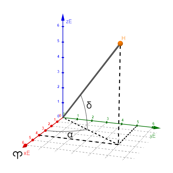
From Chart to Sky: Converting RA/Dec to Alt‑Az (Topocentric)
A core observing workflow is turning a catalog position (usually in RA/Dec) into a pointing on your sky (Alt‑Az). Software handles this in milliseconds, but understanding the steps helps you debug, plan, and operate in the field without surprises.
Inputs you need
- Your observing site latitude φ and longitude λ (east positive).
- The object’s RA and Dec (often ICRS/J2000).
- The current time in UTC (and date).
- Optional: temperature and pressure (for refraction), proper motion (for stars), and topocentric parallax (for solar system objects).

Step‑by‑step outline
-
If needed, update the coordinates to the observation date.
- For most stars at typical amateur scales, using J2000 positions is fine. For small fields, long focal lengths, or high motions, precess RA/Dec from J2000 to the date‑of‑observation equator and equinox, and apply proper motion.
- For planets, asteroids, comets, or the Moon, use a topocentric ephemeris that already accounts for parallax and light‑time. See Using Catalogs and Ephemerides.
- Compute Local Sidereal Time (LST). From UTC, obtain Greenwich Mean Sidereal Time (GMST) for the date/time, then add your longitude: LST = GMST + λ (east positive). Many planetarium apps and mounts provide LST directly. See Timekeeping for Observers and FAQs for quick estimation methods.
- Compute Hour Angle (H). H = LST − RA. Interpret H carefully in hours or degrees as needed (1h = 15°). Negative H means the object is east of the meridian; positive H means west.
-
Convert to Alt‑Az. Using your site latitude φ, declination δ, and hour angle H, compute altitude h and azimuth A. A commonly used relationship for altitude is:
sin(h) = sin(φ)·sin(δ) + cos(φ)·cos(δ)·cos(H) Similar spherical trigonometry gives azimuth. Most observers rely on software or a mount’s controller to perform these conversions internally.
- Apply atmospheric refraction (optional but recommended). For rough pointing above ~15°, a standard refraction model is fine. Near the horizon, use your local pressure and temperature for improved accuracy. See Horizon Coordinates, Refraction, and Airmass.
Meridian advantage: Targets are highest and suffer the least extinction near transit (H ≈ 0). If an object culminates uncomfortably low, consider observing it near its upper culmination if circumpolar, or pick a date when it transits higher.
Practical Star‑Hopping and Planning Techniques
Star‑hopping is the art of navigating from a known bright landmark star to a faint target using asterisms and charted patterns. Even in the era of GoTo mounts, it remains an empowering skill and a backup when electronics falter.
Tools that make star‑hopping easier
- Finder scopes (especially right‑angle, correct‑image models), reflex sights (like a Telrad or red‑dot), and low‑power eyepieces with a wide true field of view help you match star patterns between sky and chart.
- Printed atlases with multiple chart scales (e.g., a wide overview and a detailed inset) let you zoom in stages. Digital planetaria offer customizable limiting magnitudes and field‑of‑view overlays.
- Planisphere or mobile app to visualize what’s up as a function of date/time. Combine with LST intuition to schedule transits.
Workflow: from naked eye to low power to target
- Orient with bright constellations and asterisms. Identify the meridian to note which RA is highest now (LST insight helps).
- Hop in stages. Choose a path of 2–4 degree jumps between recognizable triangles or chains of stars. Use the finder to make the first hops, then switch to a low‑power eyepiece for finer hops.
- Confirm fields. Rotate your star atlas to match the eyepiece orientation. Note the expected separations and position angles between key stars to avoid false positives.
- Refine and observe. Once on the target, increase magnification as seeing and surface brightness allow. For extended objects, consider a nebula filter or averted vision.
Scheduling and prioritizing targets
- Transit windows: Use LST to find when targets reach maximum altitude. Observe low‑contrast objects (face‑on galaxies, faint nebulae) near transit to minimize extinction.
- Altitude constraints: Many observers use a 30° practical minimum for demanding targets to avoid refraction and skyglow. For casual viewing, 20° is often workable; for critical measurements, aim higher.
- Sequence by airmass: Start with objects setting in the west, then swing eastward; mix in circumpolar targets between time‑sensitive windows.
- Moon management: Schedule dark‑sky‑dependent targets away from moonlight. Use ecliptic knowledge from Ecliptic Coordinates to anticipate the Moon’s path.
Tip: Add “post‑meridian repeats.” If you missed a target before transit, the same altitude occurs after transit at the same absolute hour angle, subject to refraction asymmetries near the horizon.
Using Catalogs and Ephemerides: J2000, ICRS, and Of‑Date Positions
Most deep‑sky objects and stars in atlases are listed in equatorial coordinates referenced to the ICRS/J2000 frame. For many observing tasks, you can use those coordinates directly—your software or mount will quietly account for precession to the current date. But some contexts demand more care.
J2000 vs ICRS vs of‑date
- ICRS (International Celestial Reference System) is a high‑precision reference frame defined by distant extragalactic sources. J2000 coordinates commonly used in catalogs are closely aligned with ICRS; for most practical purposes, the difference is negligible.
- Of‑date (or “apparent place”) means coordinates referred to the equator and equinox of the observation date. This accounts for precession (and often nutation and aberration) relative to J2000.
Topocentric ephemerides
For solar system targets, use a topocentric ephemeris that accounts for the observer’s location (parallax), light‑time, and planetary dynamics. Public services and software provide these, typically based on modern planetary theories. These outputs can be fed directly into pointing or planning, and many include the target’s altitude, azimuth, illumination fraction, and rise/transit/set times.
Proper motion in catalogs
If you’re slewing to high‑proper‑motion stars, check the catalog’s proper motion fields and propagate to the date of observation. Many planetarium programs will perform this automatically when you set the date/time. For typical star‑hopping, the differences over short periods are small, but for tight fields or long intervals they matter.
For the mathematics of precession and nutation and how they affect RA/Dec, revisit Precession, Nutation, Aberration, and Proper Motion.
FAQs, Part 1: LST, Epochs, and Daily Planning
How can I estimate Local Sidereal Time (LST) without software?
Use seasonal anchors and the 4‑minutes‑per‑day rule. Around the March equinox, at local midnight LST ≈ 12h; around the September equinox, LST ≈ 0h at local midnight. Each month, LST at a given clock time advances about 2 hours; each day, it advances about 4 minutes earlier. Adjust for your longitude relative to your time zone’s reference meridian. For precise work, consult Timekeeping for Observers tools that compute GMST and LST directly from UTC.
Should I use J2000 or of‑date coordinates?
For most observational tasks, start from J2000 (ICRS) catalog positions and let your software or mount handle precession to the date. If you’re doing precision pointing with tight fields, long‑term comparisons, or astrometry, ensure your workflow uses of‑date “apparent places” and applies proper motion (and, if needed, nutation and aberration). See Using Catalogs and Ephemerides and Precession, Nutation, Aberration, and Proper Motion.
What’s the relationship between hour angle (H) and altitude?
Hour angle measures how far in time an object is from transiting your meridian: H = LST − RA. Altitude depends on H, declination δ, and your latitude φ. Near transit (H ≈ 0), the object is at its highest altitude. The altitude formula given in From Chart to Sky shows how altitude decreases as |H| grows from 0 to ±6h (±90°), reaching the horizon when geometry allows.
What’s the best time to observe faint galaxies or nebulae?
When they are highest (near transit) and the sky is darkest. Use LST to anticipate transit, avoid observing too close to the Moon, and aim for low airmass (high altitude). Prioritize targets that are setting first, then move eastward as the night progresses. For more, see Practical Star‑Hopping and Planning Techniques.
FAQs, Part 2: Refraction, Alt‑Az vs EQ, and Chart Pitfalls
How much does atmospheric refraction affect pointing?
Near the zenith, refraction is negligible. At 45° altitude, it’s small but nonzero; near the horizon it grows to roughly half a degree under standard conditions. For visual observing above ~15°, a standard refraction correction is adequate; for precision work at low altitudes, include your local pressure and temperature and consider more detailed models. See Horizon Coordinates, Refraction, and Airmass.
Why does my eyepiece view look rotated or mirrored compared to the chart?
Optical accessories change image orientation. Straight‑through refractors typically invert the image; diagonal mirrors can mirror and/or rotate depending on type; Newtonian reflectors rotate the field. Many charts and planetarium apps can flip/rotate the chart to match your view. When star‑hopping, always match orientation before making fine hops. Though related to equipment, this visualization step is crucial in practical navigation.
Do I need to account for nutation and aberration?
For visual observing and most amateur imaging, precession and proper motion are the dominant long‑term effects. Nutation (arcseconds) and annual aberration (~20″) are important for precise astrometry but usually negligible for finding objects. Software often applies them when you choose “apparent place” or “of‑date” coordinates. See Precession, Nutation, Aberration, and Proper Motion.
Why doesn’t the planet appear where my star chart shows it?
Printed star charts often show planets only for specific dates or omit them entirely. Planets move against the star background, sometimes quickly. Use a topocentric ephemeris for the date/time of observation, or set your planetarium software to your current date/time and location. See Using Catalogs and Ephemerides.
Conclusion
Celestial coordinate systems and astronomical timekeeping form the navigational grammar of the night. Equatorial coordinates tie you to catalogs and charts; horizon coordinates place targets in your local sky; ecliptic and galactic frames reveal physical structure; and time scales like UTC, UT1, and sidereal time keep it all synchronized. With a firm grasp of precession, refraction, and practical transformations from RA/Dec to Alt‑Az, you can plan efficiently, point accurately, and extract more from each observing session.

The next step is simple: pick a few targets that culminate in your next clear window, practice converting their RA/Dec to hour angle and altitude, and execute a star‑hop with confidence. Keep this guide handy, follow the internal links to refresh concepts as needed—LST, transformations, and star‑hopping—and consider exploring related topics in celestial mechanics and observational planning to deepen your toolkit.