It can be confusing when you first start to learn astronomy. What’s the best way to find the constellations? How can you learn to identify the stars? Not only can a star chart help you to explore the heavens, but it can also pinpoint objects of interest along the way. And, fortunately, a map of the stars works in much the same way as a map of the Earth! Yes, it may be old school, but once you learn to read a star chart, you’ll be set.
Why Do You Need a Star Chart?
Have you ever stood underneath a clear, starry sky and not known what you were looking at? Maybe you already know the Big Dipper and would like to discover more. Or, possibly, you’re already a little familiar with the constellations and are looking to delve a little deeper.
That’s where a star chart comes in. Learning how to read a star chart is as essential as learning how to operate your equipment, as without a star chart, you won’t know how to find your way around the sky. This article will cover the basics, explain how to read a star chart and how to get the most out of it.
What is a Star Chart or Star Map?
A star chart is literally a map of the heavens. Just as a map of the Earth will show you the different countries and cities, so a map of the sky will show you the constellations and their stars. Similarly, a terrestrial map will also show you the locations of lakes, mountains and volcanoes, while a celestial chart will also show you nebulae, star clusters and galaxies.
More than that, a chart of the night sky uses a grid reference system – similar to latitude and longitude on maps of the Earth – that can help you to easily locate and identify thousands of potential observing targets.
What is Right Ascension and Declination?
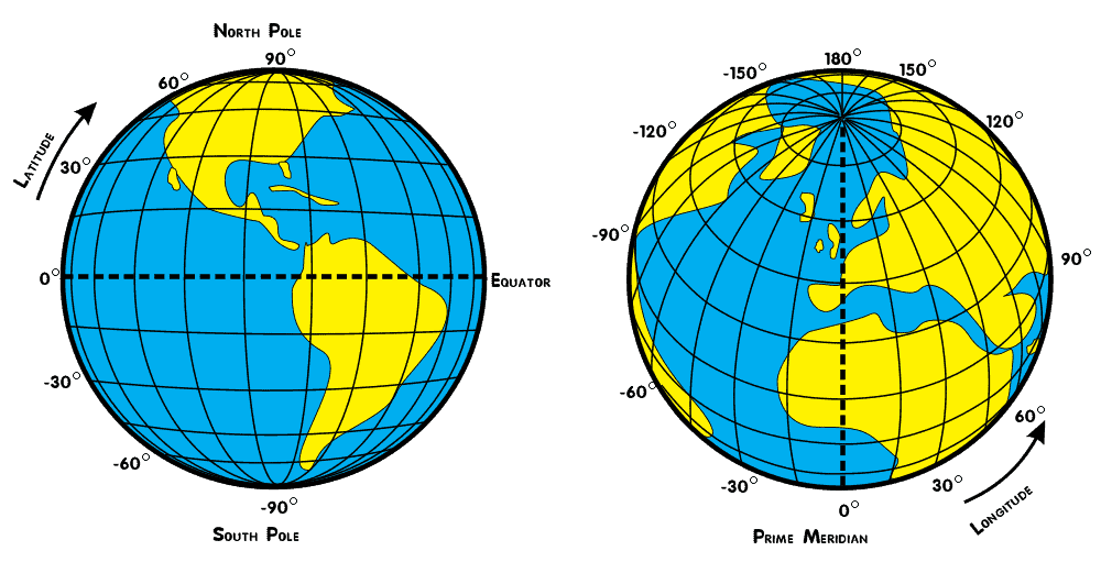
Maps of the Earth use a coordinate system called latitude and longitude to record the precise location of a town, city or feature on the surface of the Earth. More specifically, latitude denotes how far north or south of the equator a location is, whereas longitude specifies how far east or west of Greenwich, England, a location is.
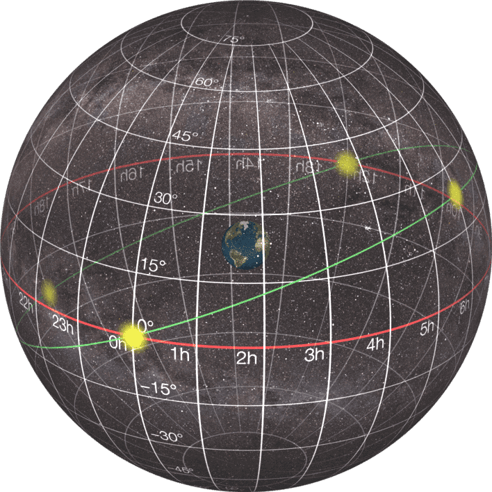
A star map works in a similar fashion, but instead of latitude there’s declination and instead of longitude there’s right ascension. We’ll come back to these terms in a moment, but there’s one other important difference to be aware of.
When you look at a map or globe of the Earth, you’re looking at it as though you were looking from above, rather than actually standing on its surface.
It’s the opposite when you look at a map of the stars. Instead of looking down at a sphere, you’re actually looking up at one because we’re standing on the Earth and looking up at the sky. In fact, the ancients imagined the stars to be affixed to a sphere that surrounded the Earth.
Although that’s not literally the case, it’s a good way to think of the sky and astronomers still refer to the sky above as the celestial sphere.
So when astronomers started to plot the positions of the stars, they needed a system to specify where on the celestial sphere a star can be found. It only made sense then, to base that system upon the maps already in existence for the Earth.
As we learned, instead of latitude, a star map uses declination. On maps of the Earth, latitude is measured in degrees and can be any number from -90 to +90. Negative values denote locations in the southern hemisphere and positive values denote locations in the northern hemisphere. A value of zero is, of course, the equator.
Declination on a star map works the same way. Declination is also measured in degrees and any negative value denotes a location in the southern celestial hemisphere, while any positive value denotes a location in the northern celestial hemisphere. Similarly, a value of zero is the celestial equator.
(Objects in the northern celestial hemisphere are best seen in the northern hemisphere on Earth, while the reverse is true for objects in the southern celestial hemisphere.)
Degrees are further broken down into arcminutes (from 0 to 60) and arcseconds (again, from 0 to 60), although it’s important to note that no arcminute or arcsecond value will ever be 60 as that would, technically be zero. (Just as minutes and seconds on a clock go from 59 to 0.)
The celestial equivalent of longitude works a little differently. On maps of the Earth, longitude is also measured in degrees, with values ranging between -180 and +180. Negative values denote locations west of Greenwich, England, while positive values denote locations east of Greenwich.
Zero degrees longitude is technically known as the prime meridian, an invisible line from pole to pole that passes through the Royal Observatory in Greenwich. (Greenwich is a borough of London and the observatory is still there. Visitors can stand astride the meridian and have one foot in the east and one foot in the west!)
The big difference here is that a star map uses right ascension, which is measured in hours, minutes and seconds, rather than degrees. The celestial sphere takes almost 24 hours to rotate above us, and so right ascension is measured as anything from zero to twenty-four.
(Technically, no object has a right ascension of exactly 24 hours, as that would reset back to zero, just as a clock moves from 23:59 to 00:00.)
On a star chart, zero hours, zero minutes and zero seconds (simply known as zero hours) is the point where the Sun crosses over from the southern celestial hemisphere into the northern celestial hemisphere, and lies precisely on the celestial equator. This happens once a year in late September at the vernal equinox.
Zero hours right ascension and zero degrees declination currently lie in the constellation of Pisces. (It will move over the millennia, but that’s a subject for another time!)
Lastly, you’ll often see right ascension abbreviated as R.A. and written as XXh XXm XXs, where h is hours, m is minutes and s is seconds. Declination is sometimes abbreviated as Dec and is written as XX° XX’ XX’’, where ° is degrees, ‘ is arcminutes, and ‘’ is arcseconds.
How Can You Find Objects on a Star Chart?
A star chart will have the right ascension printed along the top and bottom, and the declination along the sides. The chart itself will have the appearance of a grid, with vertical lines denoting right ascension and horizontal lines representing declination intersecting.
By knowing an object’s right ascension (R.A.) and declination, you can therefore locate it on the chart. For example, Sirius, the brightest star in the sky, has an R.A. of 06h 46m 06s and a declination of -16° 44’ 19’’. With a declination below zero, it therefore lies in the celestial southern hemisphere.
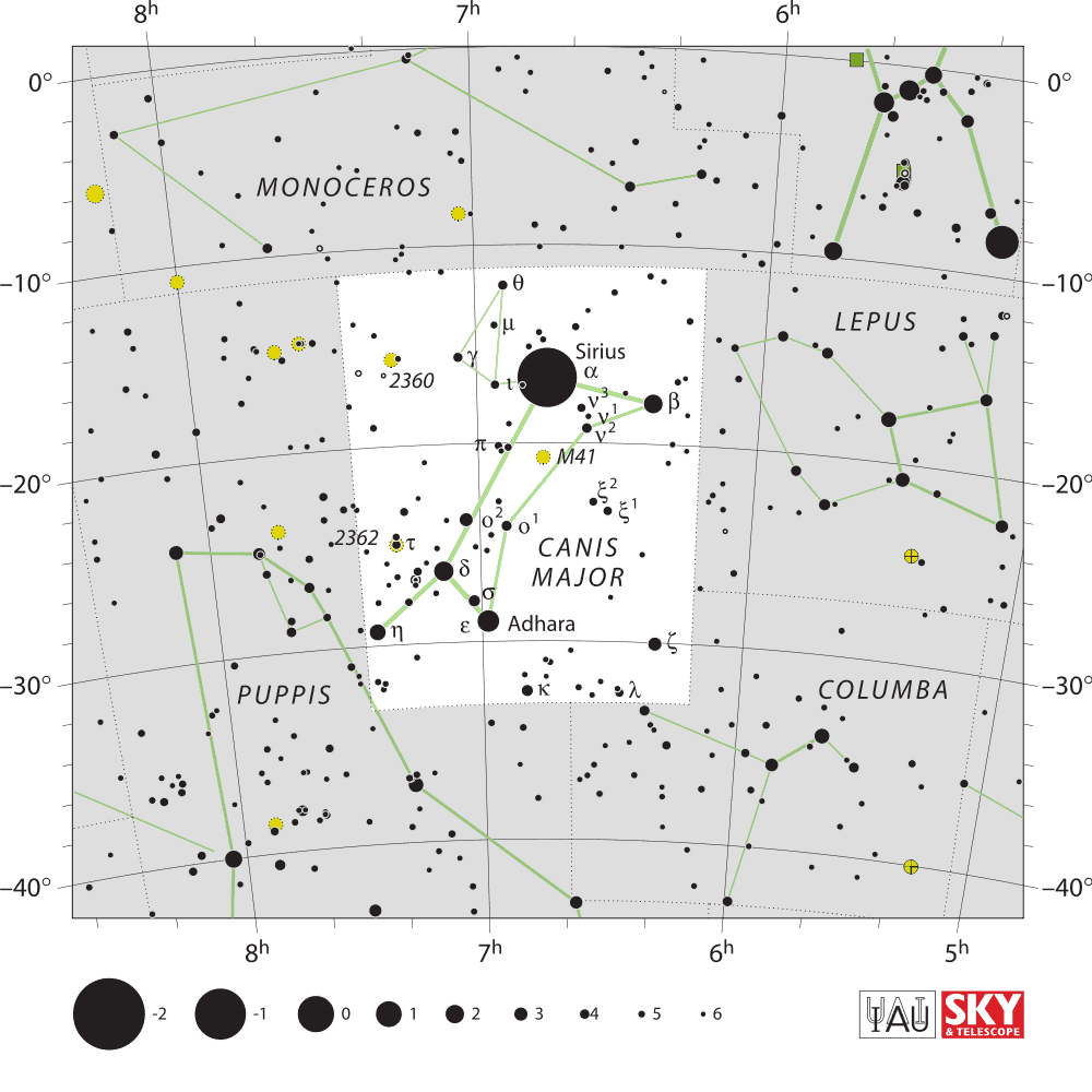
When referring to a star chart, we look along the right side for the horizontal lines denoting -10 and -20 degrees declination. We can then look across to the left until we come to a vertical line denoting 6 hours of right ascension. In the box formed between this line and the line for 7 hours of right ascension, we’ll find the star Sirius. Congratulations, you just read a star chart!
But what exactly are you looking for?
What Can You Find on a Star Chart?
Stars are represented by black dots of varying sizes, depending upon their magnitude. Put simply, magnitude is a measure of a star’s brightness, and the brighter the star, the larger the dot on the star chart.
Single stars are represented by a simple black dot, while double stars are black dot with a line through them. Variable stars – those that change their brightness over time – are represented by a black dot within a circle.
Star clusters are yellow, with open star clusters shown as a dotted circle, while globular star clusters are circles with a central cross that splits the circle into four quarters.
Nebulae are green, with diffuse nebulae depicted as the shape they appear in the sky, while planetary nebulae appear as circles with four protruding lines. Lastly, galaxies are represented by ellipses.
Here’s a great resource from NASA explaining in more detail what a nebula is.
(Don’t worry; there is, of course, always a key!)
Regardless of what you’re looking for, the size of the symbol will give you an idea of how large the object appears in the sky.
What is a Planisphere?
All of this is fine if you’re already familiar with the constellations and know where to find them, but what if you don’t? This is where a planisphere can come in. This is special star map can show you the sky as it appears from a specific latitude and at a specific time.
Since a planisphere will show you the whole sky, it’s circular, with the cardinal points of north, east, south and west labeled along the edges.
A traditional planisphere is made up of two discs; the star map itself and a mask that covers the map and hides any stars that can’t be seen. The mask has a circular window that will allow you to see which stars are currently visible.
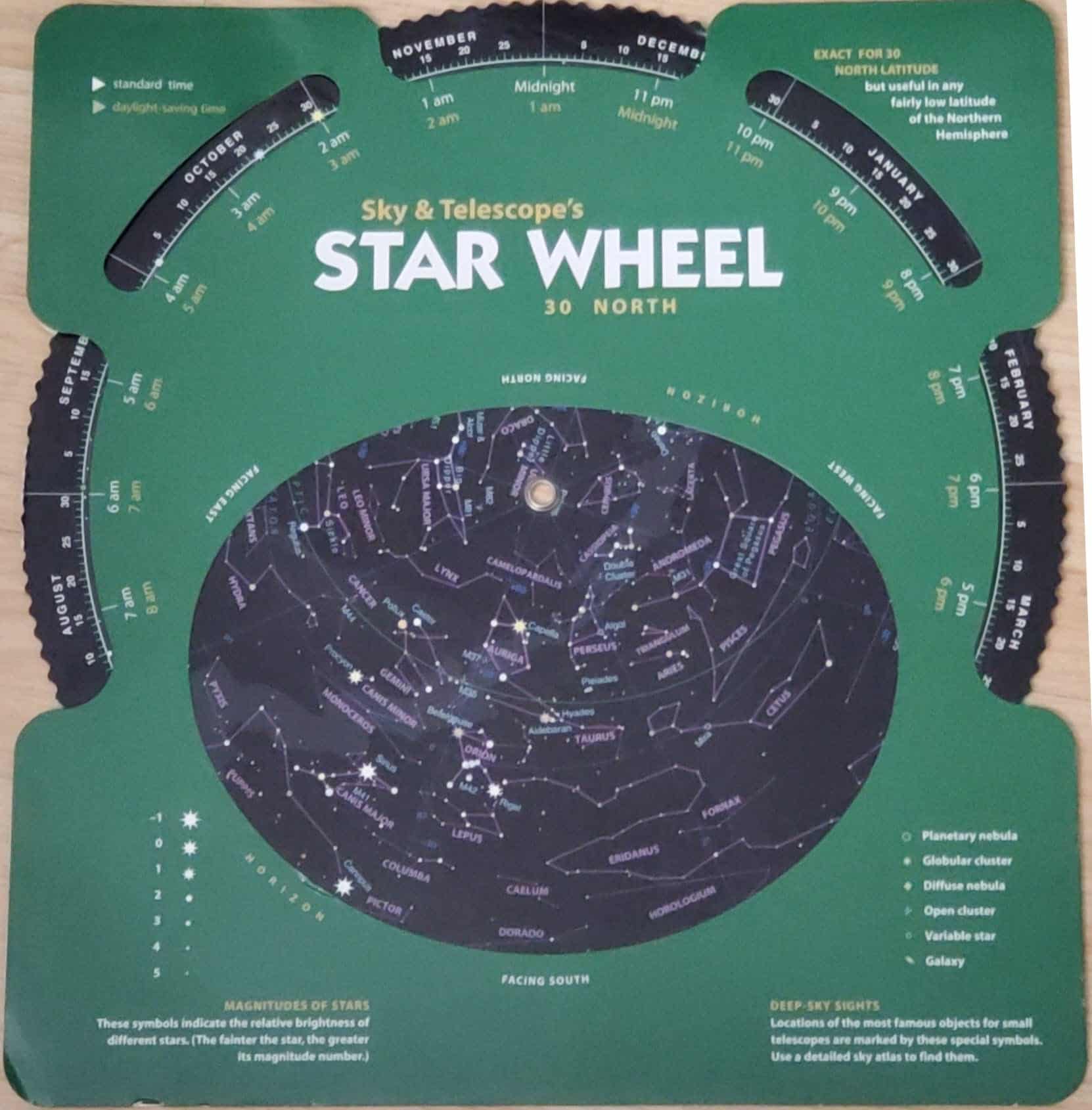
The map will have dates along its edge, while the mask will have the hours of the day. To find out which stars are visible, you simply turn the discs so that the current time is aligned with the current date.
It’s important to note that you’ll need to get a planisphere that will represent the sky from your latitude. Planispheres will vary, but some are designed to work at a specific latitude (for example, 30° North or 40° North) while others will cover a range (for example, 30° to 50° North.)
It’s best to find a planisphere for a latitude closest to your own.
To use the planisphere, first set the correct time and date and then go outside with a flashlight. (Be sure to use a red flashlight as a regular flashlight will dazzle your eyes and ruin your night vision.)
Turn to the north and turn the planisphere so that north is at the bottom. Your view of the sky should then match your planisphere. If you’re familiar with the Big Dipper, find it in the sky and on the planisphere (if it’s currently visible) to help orient yourself.
You can then turn to the east, south or west and, again, turn the planisphere in your hands so the view in the sky matches the view on your star map.
Star Chart FAQs
Star charts might seem a little confusing at first – and you might even think they’re redundant, when there are so many smartphone apps that can do the same thing. However, there’s nothing like learning the stars and constellations and being able to track down and find a desired deep sky object for yourself.
More than this, if you use a smartphone, you run the risk of ruining your night vision and, of course, a star chart isn’t dependent on a battery! With this in mind, a planisphere is the perfect tool to help you learn the constellations, while a star chart is perfect for helping you to discover the wonders within it. Happy hunting!
Pingback: Can I See Pluto And Other Dwarf Planets With A Telescope? -
Pingback: Cancer Constellation: The Ultimate Guide -
Pingback: Andromeda Constellation: It’s A Beaut! -